ATLAS INFORMATION: Atlas of the City of Wheeling, West Virginia Compiled and Drawn From Official Records, Private Plans and Actual Surveys by Otto Barherl, H. E. Halfpenny, Thos. W. Hassan and Jos. B. Doyle. Published by A. H. Mueller, 528 and 530 Locust Street, Philadelphia, PA, 1901.
The maps contained within this atlas show the names of property owners, steam railway lines, streetcar routes, and gas, water, and sewer lines. For purposes of file size, the online copies are presented in greyscale. The full-color pages (available to view at the Library by appointment) have additional information, much like Sanborn maps, indicating building materials by color.
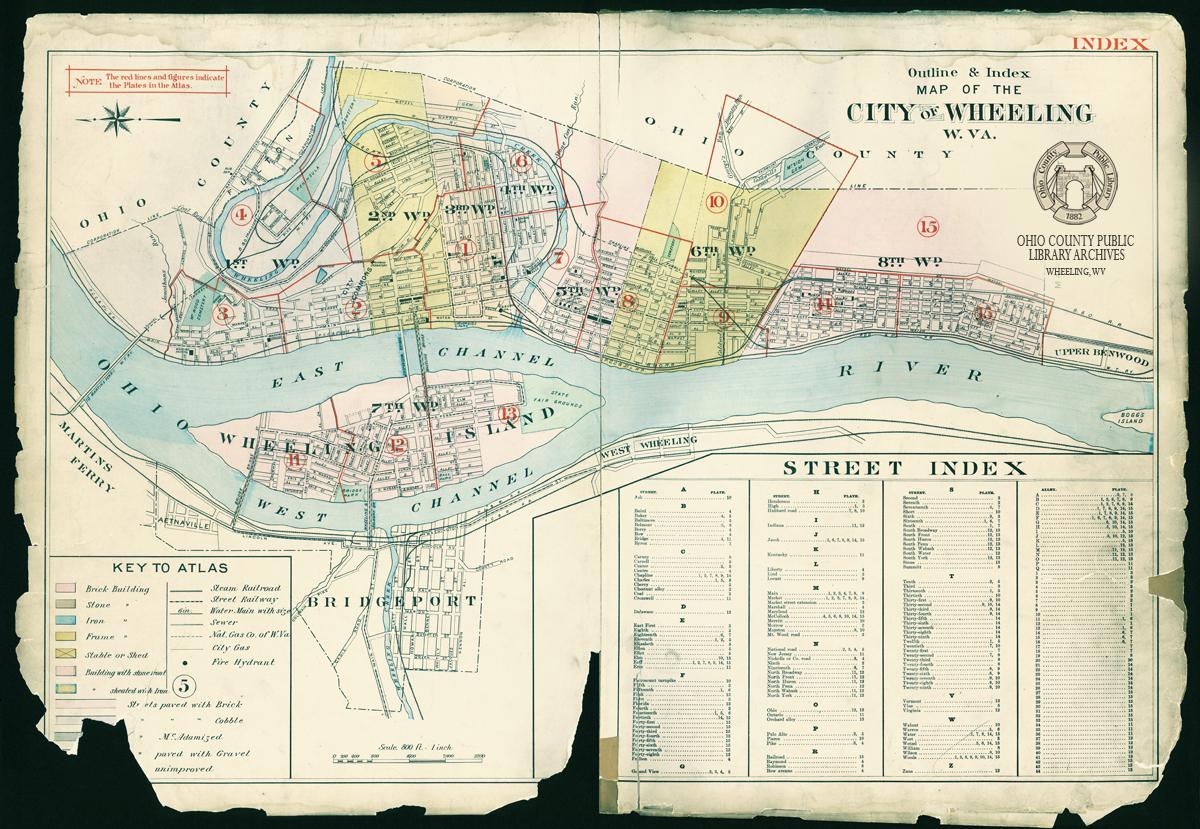
Atlas Index - Plate page descriptions and links (click to expand)
➤ Atlas Index Map: Outlines City Wards, defines plate areas, and includes map key and street index ➤ Plate 1: Ward 3 — Downtown Wheeling area from Water Street to Woods St. (west-east) and 11th to 16th (north-south) ➤ Plate 2: Wards 1 & 2 — North Wheeling and Downtown area from 6th to 11th Streets (north-south) and the Ohio River to Grandview Street (west-east) ➤ Plate 3: Ward 1 — North Wheeling and Mt. Wood Cemetery area from Jonathan's Run/Henderson Street/1st Street to 6th Street (north-south) and the Ohio River to Grandview Street/National Road/Mt. Wood Road (west-east) ➤ Plate 4: Ward 1 — North Park, Mt. Wood Cemetery, Fulton, Peninsula, & East Wheeling area from Ohio River/Top Mill to Berry Street in Fulton and Baker Street in East Wheeling (west-east) and Grandview to National Road (south-north) ➤ Plate 5: Ward 1 & 2 — Peninsula Cemetery, Gooesetown, & East Wheeling area from Baker Street to 14th in East Wheeling (north-south) and Grandview/Palo Alto Street to Wheeling Creek/Wetzel St in Manchester area (west-east) ➤ Plate 6: Wards 3 & 4 — East Wheeling, Gooesetown, & Manchester area from 14th Street to 19th Street/Wheeling Creek (north-south) and Jacob Street to Wetzel Street (west-east) ➤ Plate 7: Wards 4 & 5 — East Wheeling & Center Wheeling from 16th Street to 22nd Street (north-south) and the Ohio River to Jacob Street (west-east) ➤ Plate 8: Ward 5 — Center Wheeling from 22nd to 26th Street (north-south) and the Ohio River to McColloch Street (west-east) ➤ Plate 9: Wards 6 & 8 — Center Wheeling from 26th to 32nd Street (north-south) and the Ohio River to Woods Street (west-east) ➤ Plate 10: Wards 5 & 6 — Manchester and South Wheeling from Wheeling Creek/20th Street to 32nd Street (north-south) and Woods Street to Fairmount Avenue (west-east) ➤ Plate 11: Wards 7 — North end of Wheeling Island from west channel of Ohio River to east channel (west-east) and Bridge [Georgia] Street to Indiana Street (north-south); also includes sub plan inset of Schmulbach Addition (now Belle Isle area north of Georgia Street)
VIEWING MAP IMAGES Desktop users: To zoom in and out on map, use the scroll button on your mouse or the button in the top left-hand corner of the map. To pan left, right, up, or down, left-click and drag map. Touchscreen users: To zoom in map, use two fingers going in opposite directions. To zoom out, use two fingers moving toward each other. To pan, push map with finger in desired direction.
Atlas of the City of Wheeling, 1901: Index Page
Atlas of the City of Wheeling, 1901: Plate 1
Atlas of the City of Wheeling, 1901: Plate 2
Atlas of the City of Wheeling, 1901: Plate 3
Atlas of the City of Wheeling, 1901: Plate 4
Atlas of the City of Wheeling, 1901: Plate 5
Atlas of the City of Wheeling, 1901: Plate 6
Atlas of the City of Wheeling, 1901: Plate 7
Atlas of the City of Wheeling, 1901: Plate 8
Atlas of the City of Wheeling, 1901: Plate 9
Atlas of the City of Wheeling, 1901: Plate 10
Atlas of the City of Wheeling, 1901: Plate 11
Atlas of the City of Wheeling, West Virginia Compiled and Drawn From Official Records, Private Plans and Actual Surveys by Otto Barherl, H. E. Halfpenny, Thos. W. Hassan and Jos. B. Doyle. Published by A. H. Mueller, 528 and 530 Locust Street, Philadelphia, PA, 1901.
Physical copies of this atlas available to view at the Library by appointment. Please call 304-232-0244 or email [email protected].


 ATLAS INFORMATION: